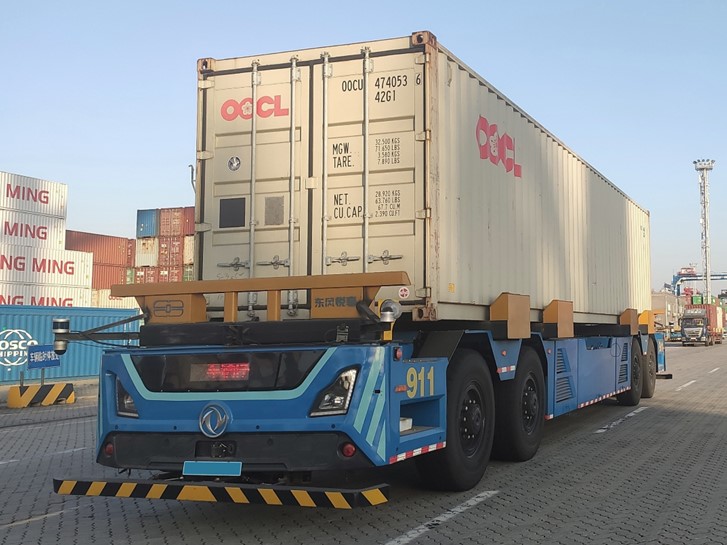
Port operations sit at the centre of global trade, and the gap between rising container volumes and the labour available to move them has widened every year since 2020. Autonomous vehicles, ranging from heavy automated guided vehicles (AGVs) through automated terminal tractors and intelligent guided vehicles (IGVs), are now central to how operators plan to close that gap. But a port is not a highway. Container stacks, quay cranes, steel structures, and the constant motion of vessels alongside the berth all conspire to weaken or disrupt the satellite signals that autonomous vehicles depend on. Reliable port automation is, before anything else, a positioning problem, and solving it requires a navigation architecture designed for the environment rather than adapted to it. CHC Navigation builds that architecture as a coordinated set of GNSS plus inertial products, deployed end to end across the terminal.
GNSS alone is rarely enough in a port. The same signal blockage that hides one truck from satellite view repeats every time a vehicle moves under a crane or between two stacked containers. Tightly coupled GNSS plus INS systems compensate by fusing satellite measurements with inertial sensor data: when satellite geometry is strong, GNSS keeps the inertial drift bounded; when satellites are blocked, the IMU carries position forward without losing the vehicle's heading. The result is centimetre-level positioning that performs reliably in real-world port conditions, using a scalable architecture that can be applied across yard trucks, marine vessels, and other port automation platforms. The article below extends our earlier note on autonomous vehicles in port operations by walking through the full product portfolio that supports a fully integrated terminal.
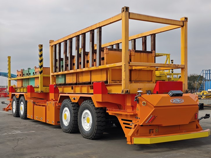
GI-610 high-performance tightly coupled GNSS/INS system keeps autonomous tractors on track at shipping terminals.
A Reliable Navigation Core for Autonomous Port Vehicles
At the heart of autonomous port operations is the vehicle navigation unit. This is the sensor that takes raw GNSS signals from multiple constellations, fuses them with inertial measurements, and outputs the position, attitude, and velocity that the vehicle's autonomy stack consumes for path planning and control.
Our 2024 article walked through this layer with the CGI-610 as a single-product anchor. The product is still the right starting point. What has broadened in the two years since is the rest of the portfolio that surrounds it on a real terminal, and the sections below walk through how the same tightly coupled GNSS plus INS architecture now extends from fleet-grade vehicles to marine and yard infrastructure and to validation rigs.
The CHCNAV CGI-610 is built for this role in heavy port environments. It is a tightly coupled dual-antenna GNSS plus INS system that delivers position, attitude, and velocity at up to 100 Hz. The dual-antenna configuration matters in port operations because heading accuracy does not degrade when the vehicle is stationary or moving slowly; both states are common in container-handling workflows where AGVs queue, dock against quay cranes, or perform fine alignment under racks. The high update rate is what lets a control stack run a tight inner loop on steering and throttle without waiting for a fresh fix.
For broader fleet deployment, particularly automated terminal tractors and intelligent guided vehicles that travel longer runs between yard zones, the CHCNAV CGI-230 takes a different optimisation. It is an automotive-grade GNSS plus INS system that combines GNSS, inertial sensing, and dead reckoning, with vehicle interfaces designed for production deployment. A port operator scaling from a pilot fleet to a fully automated yard cares about installation time, integration with the vehicle's CAN bus, and behaviour during temporary signal loss as the fleet grows. The CGI-230 targets that scaling profile directly. It maintains continuity through brief outages without requiring an external IMU module, which simplifies the sensor stack on each vehicle.
Used together in a single terminal, the CGI-610 and CGI-230 cover both the precision-heavy slow-motion work at the quay and the fleet-grade movement across the yard, drawing on the same GNSS plus INS principles but tuned to two different operating profiles.
Extending Automation Across the Entire Port Ecosystem
Port automation does not stop at the autonomous vehicle. A modern terminal is a system in which yard movements, quay cranes, vessel-side operations, and perimeter assets all need to share the same spatial reference. Positioning has to extend across every layer of that system, including the parts that sit outside the vehicle.
Positioning is one layer in a wider connectivity stack. V2X messaging over 5G carries the real-time traffic, obstacle, and routing updates between vehicles and infrastructure that a terminal control system runs on. GNSS sits underneath that stack as the shared spatial and time reference the messages depend on. The two layers are complementary, and the value of a coherent GNSS plus INS architecture is that it gives every connected element on the terminal the same position frame and the same time base to work against.
The CHCNAV P2 is positioned for this broader role. As a high-precision GNSS sensor built for harsh industrial and marine conditions, it supports applications that include reference station deployments at the terminal perimeter, position monitoring on quay equipment, and marine-side positioning where the GNSS environment is complicated by metal superstructures and the sea state itself. Putting a consistent GNSS reference at multiple anchor points on the terminal lets every autonomous vehicle work against the same ground truth, which is what stops automation projects from drifting into separate coordinate frames as they scale.
Underneath the system-level products sits the inertial backbone. The CHCNAV CI-710 is a high-precision MEMS IMU designed for demanding motion sensing in robotic and automated systems. In port automation, it shows up in places that are easy to overlook: the motion sensor on a stacking crane that needs accurate roll and pitch under wind load, the inertial unit in a SLAM-based mapping rig used for yard layout updates, or the motion measurement in a robotic system that handles perimeter inspection. Components like the CI-710 are how a port stops being a collection of stand-alone automated machines and becomes a fleet of cooperating systems with consistent motion data feeding the central coordination layer.
The cumulative effect is a single positioning framework. Vehicles, infrastructure, and marine assets all reference the same satellite constellations through the same architectural pattern, which is what unlocks integrated terminal operations rather than isolated automation pilots.
For an operator phasing automation in over several years, the coordination value of a shared positioning architecture compounds. A pilot AGV fleet running on CGI-610 units can extend later to terminal tractors on CGI-230 units without rewriting the coordinate plumbing, because both products deliver position in the same geodetic frame and the same time base. Adding a P2 reference station at the new yard expansion brings that section online inside the same network. Adding CI-710 motion sensing to a stacking crane upgrade gives the central system real-time motion data in the format it already understands. Each step adds capability without forcing a re-architecture, which is what keeps a long-term automation programme on schedule.
Ensuring Performance Through Testing and Validation
Autonomy at scale lives or dies on validation. Before an AGV runs a live container handover, before a terminal tractor hauls a real chassis between two zones, the system has to be tested against ground truth that is more accurate than the production sensor. Otherwise there is no defensible way to certify that the vehicle is doing what its safety case requires, and there is no signal to feed back into the perception and control algorithms when behaviour drifts.
The CHCNAV CGI-830 is built for that validation role. It pairs a tightly coupled GNSS receiver with a higher-grade MEMS inertial unit to produce reference-grade position, attitude, and velocity data, and it is designed to install on a test vehicle alongside the production navigation stack. The data it captures becomes the ground truth against which the vehicle's onboard solution is benchmarked. Engineering teams use that comparison to characterise performance across edge cases, identify failure modes that would not appear on a sunny straight stretch of yard, and tune algorithms for the particular geometry of the port.
The validation cycle runs continuously through deployment. A new container layout, a new crane installation, or a new section of automated lane all change the GNSS environment in subtle ways, and a port that takes automation seriously will re-validate after each. Treating validation as a permanent capability rather than a pre-launch milestone is what keeps an automated terminal trustworthy as the physical environment evolves.
The same ground truth dataset earns its keep beyond pre-launch acceptance. It supports incident review when an autonomous vehicle behaves unexpectedly, it underpins the periodic recalibration of the production navigation stack, and it gives the engineering team a defensible reference when a regulator or insurer asks for evidence. A port that has invested in a CGI-830 reference rig can answer those questions in hours rather than months, which is one of the under-discussed reasons disciplined validation pays back.
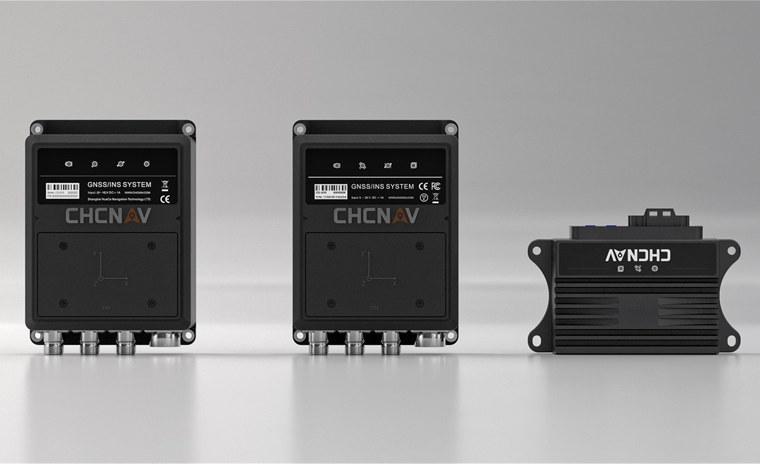
CGI-830, CGI-610, and CGI-230 GNSS + INS sensors combine GNSS positioning with inertial navigation technology to deliver reliable, high-accuracy positioning and orientation in dynamic environments.
Driving the Future of Smart Ports
The way port automation is moving is clear enough. Individual autonomous vehicles, isolated automation pilots, and one-off proofs of concept are giving way to integrated terminal systems where every moving asset and every fixed reference point shares the same positioning architecture. The product mix needed to support that integration is correspondingly broad, but the underlying engineering is consistent: tightly coupled GNSS plus inertial sensing, deployed at the vehicle, the infrastructure, the marine asset, and the validation rig.
CHC Navigation supports each of those layers with products that are designed to interoperate. The CGI-610 and CGI-230 cover the vehicle layer at two operating profiles. The P2 extends positioning to harsh and marine sections of the terminal. The CI-710 provides the motion-sensing component that makes robotic and crane subsystems part of the same network. The CGI-830 closes the loop with reference-grade validation data. As ports continue to modernise, this kind of coordinated portfolio is what lets an operator move from automation as a project to automation as the way the terminal runs.
Reliable positioning is the foundation underneath that transition, and building it with a single coherent GNSS plus INS architecture is the most direct path from today's pilots to tomorrow's intelligent terminals.
____
About CHC Navigation
CHC Navigation (CHCNAV) develops advanced mapping, navigation, and positioning solutions designed to increase productivity and efficiency. Serving industries such as geospatial, agriculture, machine control and autonomy, CHCNAV delivers innovative technologies that empower professionals and drive industry advancement. With a global presence spanning over 140 countries and a team of more than 2,200 professionals, CHC Navigation is recognized as a leader in the geospatial industry and beyond. For more information about CHC Navigation [Huace:300627.SZ], please visit: https://www.chcnav.com/about/overview
Get a Tailored Solution
Speak with CHCNAV experts to enhance efficiency and safety in high-traffic port environments, with GNSS/INS vehicle automation solutions.