CHCNAV Celebrates Earth Day with Sustainable Geospatial Innovations
2025-04-22
Honoring Earth Day with Purposeful Geospatial Innovation
Celebrated annually on April 22, World Earth Day is a global initiative that highlights the urgent need for environmental protection and sustainable development. In a world shaped by rapid urbanization, climate change, and resource scarcity, technology plays a vital role in providing scalable, long-term solutions for a healthier planet.
At CHC Navigation (CHCNAV), our mission of “Building a Smart World with Precise Spatiotemporal Information” places environmental responsibility at the core of our innovations. Whether it is reducing emissions in agriculture or increasing efficiency in infrastructure projects, our technologies enable industries to make data-driven, environmentally conscious decisions.
This Earth Day, we reaffirm our commitment to using precision technology to support sustainability, reduce waste, and encourage the smarter use of the world’s resources.
Empowering Sustainable Practices with Precision Technology
At CHC Navigation, precision goes beyond accuracy: it is a driver of sustainability. By enabling industries to operate with greater efficiency and control, our technologies help reduce environmental impact across a wide range of sectors.
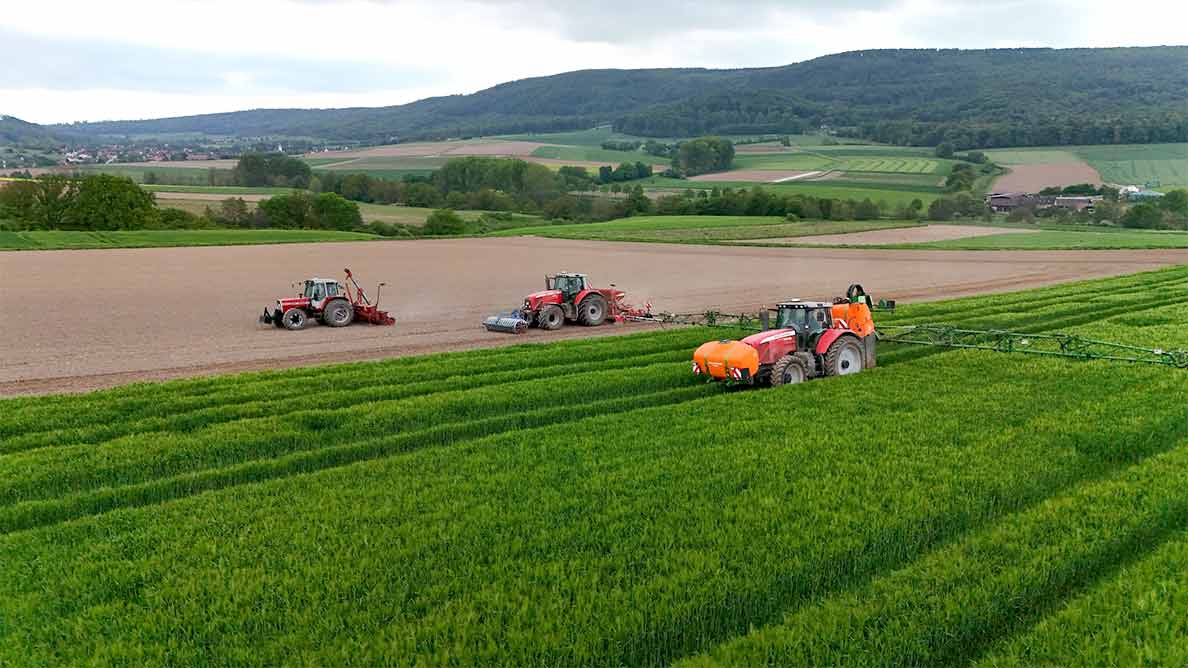
Smarter Agriculture with Fewer Inputs and Higher Yields: CHCNAV’s precision agriculture solutions, such as the NX612 Autosteering System, enable farmers to optimize every pass of planting, spraying, and harvesting. By eliminating overlaps and reducing operational errors, these systems reduce fuel consumption, and minimize water, fertilizer, and pesticide use. The result is healthier soil, reduced runoff into rivers, and fewer emissions from machinery, supporting both productivity and environmental stewardship.
CHCNAV solutions in precision agriculture
Sustainable Construction and Infrastructure Development: Infrastructure projects require significant material and energy resources. CHCNAV’s machine control systems and high-precision GNSS and LiDAR technologies including the i89 GNSS Receiver help ensure that earthmoving, grading, and layout work is executed accurately the first time. This reduces rework, limits waste of materials such as concrete and asphalt, and optimizes equipment usage. Meanwhile, solutions like the H3 GNSS monitoring receiver support the long-term maintenance of infrastructure by monitoring structural health, reducing the need for premature reconstruction and increasing resilience to environmental hazards.
Protecting and Managing Natural Resources: Geospatial technology plays a central role in land, water, and ecosystem management. CHCNAV’s drones, mobile mapping systems, and GIS tools are used to monitor forests, map river systems, and track changes in vegetation or land use. For example, the X500 UAV combined with LiDAR and full-frame cameras provides accurate inventory of forest stands for sustainable forestry. The Apache4 USV, paired with multibeam sonar and ADCP sensors, helps measure sedimentation and reservoir capacity, offering insights for water resource planning, reservoir maintenance, upstream vegetation protection and ecological restoration.
CHCNAV X500 UAV for environmental mapping
Powering Efficient and Low-Emission Autonomous Operations: Our GNSS and inertial navigation systems serve as the foundation for a wide range of autonomous platforms including drones, robots, agricultural machinery, and driverless vehicles. These systems enable high-precision tasks such as targeted spraying, automated inspections and route optimization, replacing manual, fuel-intensive operations. This shift not only reduces emissions and improves operational efficiency but also enhances safety across sectors from agriculture to urban mobility. In addition, precise positioning supports safer and more efficient traffic flow, helping to reduce congestion, minimize the risk of accidents, and indirectly reduce overall carbon emissions.
Greening Our Own Operations: A Commitment from Within
Beyond the environmental benefits delivered through our products, CHCNAV is also focused on integrating sustainability into our internal operations and company culture. Our ESG initiatives reflect a commitment to responsible business practices that reduce our own environmental footprint.
Designing Low-Carbon Products from the Start: We are embedding sustainability directly into product development. This includes prioritizing energy-efficient designs, like the low-power H3 GNSS receiver, and ensuring material compliance with environmental standards such as RoHS. We believe that durable, long-lasting products with optimized power consumption contribute to a lower lifecycle carbon footprint for both CHCNAV and our customers.
Responsible Manufacturing and Resource Management: Across our production facilities and offices, CHCNAV is working to reduce energy and water usage, promote sustainable workplace behaviors, and minimize waste. Simple steps like signage reminders to turn off lights and equipment combine with structured initiatives such as responsible hazardous material disposal and recycling programs. We are also ISO 14001 certified, ensuring that environmental management is part of our continuous improvement framework.
Collaboration and Responsible Sourcing: We recognize that creating a sustainable future is a collective effort. Through programs like our “Explorer Program” and partnerships with research institutions, we support innovation in environmental technologies. Additionally, we apply responsible procurement practices, working closely with our suppliers to uphold ethical, social, and environmental standards. Transparency, fair competition, and long-term collaboration are central to building a sustainable value chain.
Earth Day is more than a symbolic occasion - it is a global reminder of the work we all must do to protect our planet. At CHCNAV, we view sustainability as a shared responsibility and a long-term commitment that shapes our technologies, partnerships and internal operations. Through continued innovation in precision navigation, mapping, and automation, we aim to help industries reduce waste, manage natural resources more effectively, and build resilient, low-impact operations.
Our technologies are not only tools for greater efficiency, but also enablers for environmental stewardship - helping users reduce emissions, conserve materials, and make better data-driven decisions.
As we move forward, we will continue to invest in sustainable design, expand our collaboration with partners, and maintain transparency in our ESG efforts. Through technological innovation, we are empowering professionals across industries to act with precision to achieve sustainability goals without compromising productivity. This is our vision in action: building a smarter world with technologies that also protect it.
____
About CHC Navigation
CHC Navigation (CHCNAV) develops advanced mapping, navigation and positioning solutions designed to increase productivity and efficiency. Serving industries such as geospatial, agriculture, construction and autonomy, CHCNAV delivers innovative technologies that empower professionals and drive industry advancement. With a global presence spanning over 140 countries and a team of more than 2,000 professionals, CHC Navigation is recognized as a leader in the geospatial industry and beyond. For more information about CHC Navigation [Huace:300627.SZ], please visit: www.chcnav.com
Geospatial Solutions for a Greener World
Harness the power of GNSS, LiDAR, and mapping to drive sustainability, reduce emissions, and manage natural resources with precision and efficiency.