Qu'est-ce que le GPS RTK et comment améliore-t-il la précision du positionnement ?
2026-04-17
Les récepteurs GNSS standard permettent un positionnement précis à environ deux à cinq mètres sous un ciel ouvert. Pour la plupart des applications grand public, c'est plus que suffisant. Mais pour la topographie, la construction, l'agriculture de précision et la navigation autonome, une erreur de deux mètres peut signifier une fondation mal alignée, une pente de drainage dans la mauvaise direction ou un système de guidage qui dérive de sa trajectoire.
Le GPS/GNSS RTK comble cette lacune. En appliquant des corrections en temps réel à partir d'un point de référence connu, le système RTK permet d'obtenir une précision de positionnement de l'ordre du mètre au centimètre, transformant le GNSS d'un outil de localisation polyvalent en un instrument de mesure de précision. Bien que communément appelés "GPS RTK", les systèmes RTK modernes utilisent le GNSS, qui englobe plusieurs constellations de satellites, dont le GPS, le GLONASS, le Galileo, le QZSS et le BeiDou.
Cet article explique ce qu'est le RTK, comment il fonctionne au niveau du signal, où il est le plus utile et ce qu'il faut prendre en compte lors du choix d'un système GNSS compatible RTK.
Le fonctionnement du GPS standard et ses lacunes
Le GNSS (Global Navigation Satellite Systems, dont le GPS est une constellation) détermine la position en mesurant le temps de parcours des signaux émis par les satellites en orbite. Un récepteur a besoin des signaux d'au moins quatre satellites pour calculer sa position tridimensionnelle, plus une correction d'horloge. Le calcul est simple en théorie, mais plusieurs sources d'erreur dégradent le résultat dans la pratique.
Les principales sources d'erreur :
Le retard ionosphérique : lorsque les signaux traversent l'ionosphère (entre 80 et 1 000 km d'altitude), des particules chargées les ralentissent dans des proportions variables en fonction de l'activité solaire, de l'heure de la journée et de l'angle d'élévation du satellite. À elles seules, ces particules peuvent introduire des erreurs de un à cinq mètres.
Retard troposphérique : la basse atmosphère (en dessous de ~12 km) déforme et ralentit également les signaux, l'effet variant en fonction de la température, de l'humidité et de la pression. Contribution typique à l'erreur : 0,2 à 0,5 mètre.
Erreurs d'orbite et d'horloge des satellites. Même avec des horloges atomiques précises et des données d'éphémérides régulièrement mises à jour, de petites erreurs résiduelles dans la position et la synchronisation des satellites se propagent dans la solution de positionnement.
Trajets multiples : les signaux réfléchis par les bâtiments, le terrain ou les structures voisines arrivent à l'antenne par des chemins indirects, créant des interférences qui dégradent la position obtenue.
Combinées, ces erreurs limitent généralement le positionnement GNSS autonome à environ 1,5 à 5 mètres horizontalement. Pour les applications qui nécessitent une précision de l'ordre du centimètre, le positionnement autonome n'est tout simplement pas possible.
Qu'est-ce que le GPS/GNSS RTK et comment permet-il d'obtenir une précision centimétrique ?
RTK signifie Real-Time Kinematics (cinématique en temps réel). Il s'agit d'une technique GNSS différentielle qui utilise les mesures de la phase de la porteuse plutôt que les pseudo-alternances basées sur le code sur lesquelles s'appuient les récepteurs standard.
Le concept de base : Correction différentielle
La méthode RTK consiste à comparer les observations satellitaires entre deux récepteurs simultanément. L'un des récepteurs est installé à un endroit connu avec précision (la station de référence). L'autre se déplace avec l'utilisateur (le mobile). Comme les deux récepteurs observent les mêmes satellites presque en même temps à partir d'emplacements proches, ils subissent des erreurs atmosphériques presque identiques. La station de base calcule la différence entre sa position connue et la position impliquée par ses observations satellitaires, puis diffuse ces corrections au récepteur mobile en temps réel. Le mobile applique les corrections à ses propres observations, annulant ainsi les sources d'erreur partagées. Il ne reste plus qu'une solution de position très précise.
Pourquoi les mesures de la phase porteuse sont-elles importantes ?
Les récepteurs GNSS standard mesurent la pseudo-distance, c’est-à-dire la distance apparente à chaque satellite estimée à partir du temps d’arrivée du signal codé. La résolution de cette mesure est limitée par la longueur d’un chip de code, d’environ 300 m pour le code C/A sur L1 et d’environ 30 m pour le code P.
Les récepteurs RTK vont plus loin. Ils suivent l'onde porteuse elle-même, qui oscille à une fréquence beaucoup plus élevée. La longueur d'onde de la porteuse L1 est d'environ 19 centimètres. En comptant le nombre de cycles complets de la porteuse plus la phase fractionnelle, les récepteurs RTK mesurent la distance entre le satellite et le récepteur avec une résolution correspondant à une petite fraction de cette longueur d'onde.
La difficulté réside dans la résolution de l'ambiguïté : déterminer le nombre entier exact de longueurs d'onde complètes entre le satellite et le récepteur. Les algorithmes RTK modernes résolvent cette ambiguïté en quelques secondes en utilisant des données multifréquences et multi-constellations, ce qui permet au système de se verrouiller sur un point précis au centimètre près rapidement après le démarrage.
Où le GPS RTK apporte le plus de valeur ajoutée
La technologie RTK a largement dépassé le cadre de la topographie traditionnelle. Aujourd'hui, il est à la base des flux de travail de précision dans de nombreux secteurs, chacun ayant des exigences distinctes en matière de précision et d'exploitation.
Topographie et ingénierie
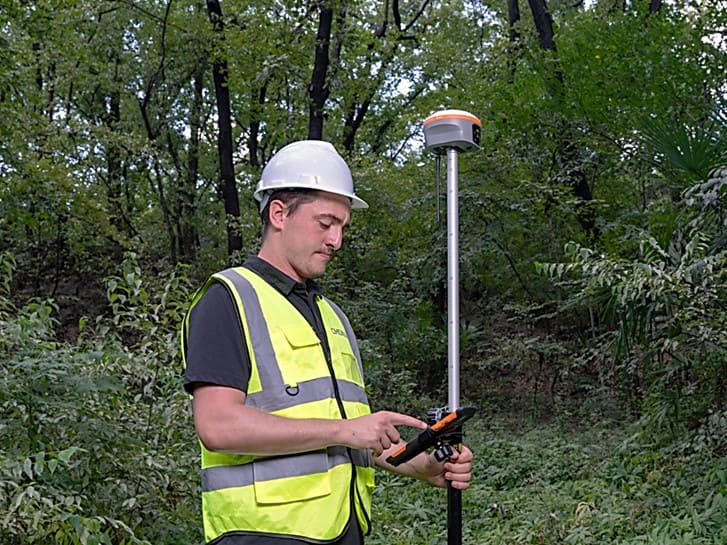
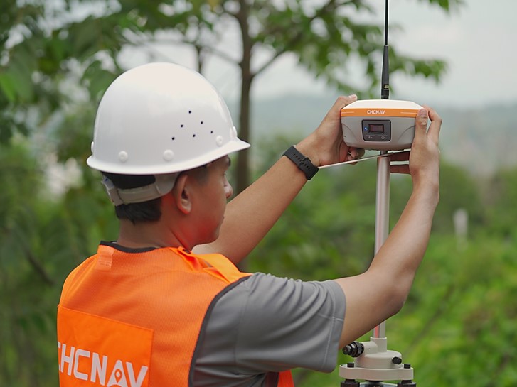
La topographie reste le cas d'utilisation fondamental. Dans les environnements à ciel ouvert, le système RTK peut remplacer ou réduire considérablement le travail de la station totale pour les levés de limites, la cartographie et l'établissement de points de contrôle, en réduisant le temps passé sur le terrain tout en conservant une précision de qualité pour les levés. Pour les levés cadastraux et d'ingénierie où la précision centimétrique est légalement ou contractuellement requise, la méthode RTK est désormais la méthode standard pour les travaux en milieu ouvert.
À droite : un ingénieur installant la station de base iBase pour fournir des corrections RTK fiables sur le terrain.
Construction et guidage d'engins
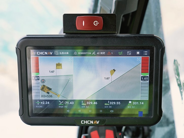
Sur les chantiers de construction, le système RTK pilote les systèmes de guidage des excavatrices, des bulldozers et des niveleuses, guidant en temps réel les engins de terrassement jusqu'à la cote de conception. Il permet également de réaliser des plans de construction (implantation des angles des bâtiments, des tracés des services publics et des routes) sans qu'il soit nécessaire de recourir à une station totale et à une personne munie d'un récepteur GPS sur canne.
À gauche : une pelleteuse est équipée du système de guidage 3D TX73 afin de faciliter la construction de routes et le terrassement avec précision.
À droite : L'écran du système affiche des instructions en temps réel, aidant les opérateurs à creuser avec précision les surfaces ciblées.
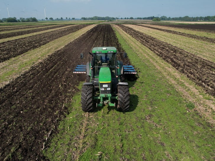
Agriculture de précision
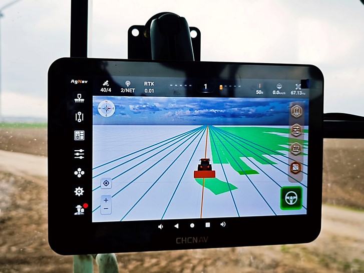
Les systèmes d'autoguidage dans l'agriculture s'appuient sur le RTK pour guider les tracteurs, les pulvérisateurs et les moissonneuses le long de lignes parallèles précises. Avec une précision de l'ordre du centimètre, le chevauchement est minimisé, les intrants (semences, engrais, produits chimiques) sont appliqués efficacement et les opérations sur le terrain peuvent se poursuivre avec précision même dans des conditions de faible visibilité.
À gauche : le système de guidage NX612 aide les opérateurs à maintenir des passages précis et parallèles dans le champ.
À droite : Tracteur équipé du système NX612 pour une préparation précise du sol et un semis efficace.
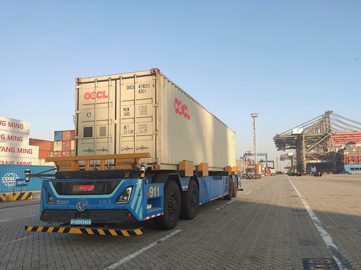
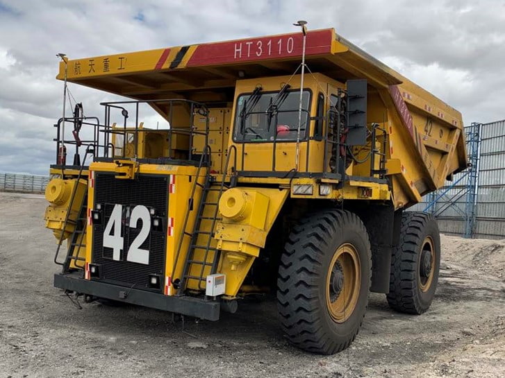
Navigation autonome et robotique
Les véhicules autonomes, les robots de livraison et les drones ont besoin d'un positionnement continu et de haute précision pour naviguer de manière sûre et fiable. La technologie RTK fournit en temps réel des données de position centimètriques dont dépendent les systèmes de fusion de capteurs (combinant le GNSS avec l'IMU, le LiDAR et les caméras) en tant que référence primaire.
À gauche : Véhicule portuaire autonome équipé du système CGI-610 GNSS/INS pour un positionnement au centimètre près et des opérations précises.
À droite : Tombereau utilisant le CGI-610 pour une navigation autonome fiable dans des environnements miniers exigeants.
Les solutions de navigation GNSS + INS de CHC Navigation sont conçues spécifiquement pour ces applications. Le système GNSS/INS CGI-610 à couplage étroit combine un positionnement RTK de haute précision avec une mesure inertielle pour maintenir une précision continue même en cas de brèves interuptions de réception GNSS causées par des tunnels, des viaducs ou des environnements urbains denses.
Composants clés d'un système RTK
Une installation RTK se compose de trois éléments interconnectés, chacun ayant un impact direct sur les performances du système.
La station de référence
La station de référence est un récepteur GNSS placé à un endroit dont les coordonnées sont connues avec précision. Elle suit en permanence les signaux des satellites et calcule les données de correction, qu'elle transmet au rover. La base peut être une unité dédiée installée sur un repère connu ou une station de référence virtuelle fournie par un réseau NRTK (Network Real Time Kinematic).
La qualité de la station est importante. Un récepteur GNSS avec suivi multifréquence et multiconstellation (GPS, GLONASS, Galileo, BeiDou) génère de meilleures corrections, car un plus grand nombre d'observations satellitaires renforce la géométrie de la solution et améliore la vitesse de résolution de l'ambiguïté. Les stations de référence conçues à cet effet, comme l'iBase CHCNAV, sont conçues pour fonctionner en continu et fournir des données de correction stables et de haute qualité 24 heures sur 24.
Le mobile
Le mobile est le récepteur qui se déplace avec l'opérateur, monté sur une canne topographique, une machine, un drone ou un véhicule autonome. Il reçoit les données de correction de la base, les applique à ses propres observations satellitaires et fournit une position corrigée en temps réel.
Pour que les corrections fonctionnent correctement, le mobile doit suivre les mêmes constellations de satellites et les mêmes fréquences que la base. La concordance des capacités entre la station et le mobile garantit que les corrections différentielles s'appliquent correctement.
La liaison de données
Les corrections RTK doivent parvenir au mobile avec un temps de latence minimal, généralement inférieur à une seconde. La liaison de données peut être une radio UHF/VHF (courante sur les chantiers de construction et dans les zones sans couverture cellulaire), un modem cellulaire (utilisant le protocole NTRIP pour se connecter aux réseaux CORS), ou une connexion Wi-Fi/Bluetooth directe pour les applications à courte portée. Le choix de la liaison de données a une incidence sur la portée opérationnelle, la fiabilité et les exigences en matière d'infrastructure. Les liaisons radio sont autonomes, mais leur portée est limitée (généralement de 5 à 10 km). Le RTK en réseau via NTRIP élimine totalement le besoin d'une station locale, en s'appuyant plutôt sur un réseau RTK régional.
Précision RTK : Ce à quoi on peut s'attendre en conditions réelles
Dans de bonnes conditions (ciel ouvert, ligne de base courte, forte géométrie du satellite), le RTK donne de bons résultats :
Précision horizontale : 1 à 2 centimètres (1 cm + 1 ppm de distance de base)
Précision verticale : 2 à 3 centimètres (typiquement 1,5 à 2 fois l'erreur horizontale)
Temps d'initialisation : de quelques secondes à moins d'une minute pour les récepteurs multifréquences modernes.
Plusieurs facteurs influencent les performances dans le monde réel :
Longueur de la ligne de base : à mesure que la distance entre la station et le mobile augmente, les conditions atmosphériques divergent et l'hypothèse de l'erreur partagée s'affaiblit. Les performances se dégradent au-delà d'une distance d'environ 10 à 15 km pour le RTK mono-station. Le RTK en réseau atténue ce phénomène en modélisant les erreurs atmosphériques régionales.
Disponibilité des satellites : les canyons urbains, le couvert végétal dense et les reliefs profonds réduisent le nombre de satellites visibles et créent des conditions de trajets multiples qui nuisent à la précision et à la vitesse d'initialisation.
Suivi de plusieurs constellations : les récepteurs qui suivent simultanément le GPS, le GLONASS, le Galileo et le BeiDou maintiennent un plus grand nombre de satellites en vue, ce qui améliore la robustesse de la solution dans les environnements difficiles.
Qualité de l' antenne : une antenne GNSS bien conçue, avec une bonne réjection des trajets multiples et des caractéristiques de centre de phase stables, contribue directement à la précision des mesures.
RTK et autres méthodes de correction
Le RTK n'est pas la seule technique permettant d'améliorer la précision du GNSS. Comprendre les alternatives permet de déterminer quand le RTK est le bon choix et quand une autre approche peut être plus pratique.
DGPS (GPS différentiel)
Le DGPS utilise des corrections basées sur des codes plutôt que des mesures de la phase de la porteuse. Il améliore la précision autonome du mètre à environ 0,5 à 1 mètre, mais ne permet pas d'atteindre une précision centimétrique. Le DGPS est plus simple et fonctionne sur des lignes de base plus longues, ce qui le rend adapté aux applications pour lesquelles une précision inférieure au mètre est suffisante (navigation maritime, collecte de données SIG).
PPP (Positionnement précis des points)
Le PPP utilise des données précises sur l'orbite et l'horloge des satellites (provenant de réseaux de suivi mondiaux) pour atteindre une précision de l'ordre du décimètre au centimètre avec un seul récepteur, sans qu'aucune station de base locale ne soit nécessaire. Le compromis est le temps de convergence : Le PPP peut prendre de 20 à 30 minutes pour atteindre sa pleine précision après le démarrage, contre quelques secondes pour le RTK. Les services hybrides PPP-RTK réduisent cet écart, mais pour les applications en temps réel qui nécessitent une précision centimétrique instantanée, le RTK reste la solution la plus rapide.
PPK (cinématique post-traitement)
Le PPK enregistre les données GNSS brutes sur le terrain et les traite ultérieurement au bureau en utilisant les données de la station de base. Il atteint la même précision que le RTK, mais sans la liaison de données en temps réel. Le PPK est largement utilisé pour la cartographie par drone et les levés aériens lorsqu'il n'est pas possible de disposer d'un flux de correction en direct. La limite est que les erreurs ne peuvent pas être détectées et corrigées pendant le travail sur le terrain.
____
À propos de CHC Navigation
CHC Navigation (CHCNAV) développe des solutions avancées de cartographie, de navigation et de positionnement conçues pour accroître la productivité et l'efficacité. Au service d'industries telles que le géospatial, l'agriculture, le contrôle des machines et l'autonomie, CHCNAV fournit des technologies innovantes qui permettent aux professionnels de se prendre en charge et de faire progresser l'industrie. Avec une présence mondiale dans plus de 140 pays et une équipe de plus de 2 200 professionnels, CHC Navigation est reconnue comme un leader dans l'industrie géospatiale et au-delà. Pour plus d'informations sur CHC Navigation [Huace:300627.SZ], veuillez consulter : https://www.chcnav.com/about/overview
Vous avez une question sur nos solutions ou nos opportunités de distribution ?